Sunday, March 27, 2011

Tent Rocks National Monument Delivers Spectacular Scenery

It can be a challenging and exciting climb to the top of the Canyon Trail at Tent Rocks National Monument but those who make it are rewarded with a striking panoramic view of the valley floor below.

From on high one can see the sparkling waters of the Rio Grande forming the lake at Cochiti dam, the spreading plains to the east, the Ortiz mountains looming in the south and the Sangre de Cristo and Jemez Moutains to the north and west.

But it is the view from behind, from where the hiker just came, that may be the most impressive as the eerie tent-shaped hoodoos for which this place is named dominate the scene.

Rising from the ground like so many dusty colored Christmas trees, the late afternoon light here in the canyon makes for impressive shadows, stunning contrasts and intriguing memories of these rock formations.

Located just south of Santa Fe near Cochiti Pueblo, the national monument has seen many improvements of late making it worth a return visit.

Gone is the bone-jarring, five-mile dirt road that used to lead to the Canyon and Cave Loop trailheads.

It has since been replaced by a smooth ribbon of asphalt and concrete pads where the road crosses several arroyos.

Visitors to the trailhead will find the easy, 1.2 mile Cave Loop trail and the more challenging and rewarding Canyon trail awaiting.

The Cave Loop trail provides a good view of the surrounding tent rocks and multi-colored hillsides along with access to a small cave carved into the rock wall by ancient dwellers.

The compelling Canyon Trail leads visitors up into a tight high-walled canyon where lone Ponderosa pines have taken root and stretch mightily for the skies.

Working one’s way up the sandy floor, squeezing at one point underneath a boulder wedged between the walls, one can’t help but feel a touch of claustrophobia.

Any anxiety produced by the tight confines soon diminishes though as one begins to climb up and out to the mesa top above. On the way one need only stop and look back to see the towering tent rocks and softly hued rock walls that make this place such a rare find.

The Canyon trail is listed at 1.6 miles with a short but steep, 630 foot ascent. The trail itself is well worn, with easily managed switchbacks and the resulting view is one of the more rewarding to be found in the state.

Upon climbing back down the canyon, hikers can take the Cave Loop trail at its intersection and find the hike is not much longer than just heading straight back to the lot. The trail ends as it threads its way through a well defined group of the tent rock formations.

The tent rocks are the byproduct of volcanic eruptions thousands of years ago that helped shape and form the Jemez region. Formed of soft pumice and tuff many of the tent rocks are protected from erosion by a cap rock perched precariously upon its peak.

The multi-colored bands seen in cliff faced walls were formed by different layers of ash piling up during long ago, volcanic events.

Posted on the BLM’s webpage dedicated to the monument is an extremely informative student trail guide that can printed out and taken along for a more inclusive hike.

A map and guide specifically dedicated to the monument published by High Desert Field Guides of Santa Fe and authored by geologists Kirt Kempter and Dick Huelster can also be obtained at the convienance store in the nearby town of Cochiti Lake or through the Public Lands Information Center which operates a store off St. Rd 14 on Dinosaur Trail.

And just a few miles up the road from the monument trailheads, visitors will find a new mile long, wheelchair suitable, hiking loop has been installed along with new picnic shelters, a modern outhouse and improved parking at the Veterans Memorial Overlook.

Here the surrounding peaks of the Jemez Mountains and views of the Sangre de Cristo Mountains dominate the horizon while Peralta Canyon and its impressive rock formations can be seen below.

The windswept bluff at the overlook is a quiet, contemplative kind of place where one might be inclined to have a picnic or relax with a good book.

Tent Rocks National Monument is also called Kasha-Katuwe (white cliffs) and is jointly managed by the BLM and Cochiti Pueblo. In 2009 the monument recorded about 50,000 visitors including 45 school groups, according to latest available manager’s report posted on the BLM’s website.

Specific rules are in place at the monument including no alcohol, mountain bikes or dogs allowed, not even those to be left in a vehicle. For more info see the BLM’s website at http://www.blm.gov/nm/st/en/prog/recreation/rio_puerco/kasha_katuwe_tent_rocks.html

The site is open during the summer hours from 7 a.m. to 7 p.m. and costs $5 for entrance.

 If You Go:

From Santa Fe take I-25 south to the turn off to Cochiti Lake at the bottom of La Bajada and follow St. Rd 16 to the intersection of St. Rd 22. Head west towards the mountains and Cochiti Dam. Just past the base of the dam turn south on 22 towards Cochiti Pueblo and the town of Sile. Follow the signs to the monument entrance.

Looking up and out from the bottom of Canyon Trail at Tent Rocks National Monument in  New Mexico.


Friday, March 18, 2011

Visit Wildlife West Nature Park to See Wild Animals Up Close

If it’s wolves you’re looking for, then the Wildlife West Nature Park in Edgewood is a good place of find them, along with plenty of other enlightening and entertaining animals.

The 122-acre park offers sanctuary for wildlife that for one reason or another could no longer survive on their own.

And for a lucky few, they have found a comfortable, natural, environment where they can live out the rest of their lives while also serving to educate and entertain the public.

The non-profit nature park is the lifework of Roger Alink, a Vietnam era Army veteran and retired high school shop teacher and host of some 4,000 school kids each year on field trips.
Roger Alink and Lucky the Deer.
Alink proudly notes that the park may be the world’s only zoo constructed entirely by youth, many of whom were Youth Conservation Corps members.

Alink, who earned a bachelor’s degree in industrial education and a master’s degree in outdoor recreation, both from the University of New Mexico, believes most kids these days suffer from “Nature Deficit Disorder.”

Alink, who grew up on a farm in Minnesota, did his best to combat that condition among his students while serving as shop teacher for Albuquerque’s Valley High School, where he ran an after-school stock car racing club and a mountaineering club.

The clubs helped give kids confidence, experience and skills they’d need in the outside world.

Alink, 63, is married to Terrie and is the father of two of his own children. His son, Brian, works in finance in Dallas and his daughter, Emily, is an industrial designer living in Seattle. Alink is the proud grandfather of six.

But Alink had an even bigger dream for helping kids, and that’s why he undertook creation of the nature park.

It’s a place where “education, nature, and hands-on experience with everything from animal husbandry to construction and conservation, provides a unique learning and development experience for young people,” Alink states on his website at www.wildlifewest.org.

During a recent visit to the park, Alink, a licensed contractor, pointed out how many of the park facilities incorporate recycled materials including animal enclosures made out of used tires encased in stucco.

The park’s amphitheatre is constructed of steel beams, poles and siding recovered from a defunct Albuquerque nursery.

There’s a water catchment and containment system to provide additional water for the facility, gardens that produce vegetables for the animals and even a small pond and wetland area to provide natural habitat.

Alink notes out that many of the park’s animal enclosures incorporate native trees, rocks and other features which provide the animal with a natural environment in which to live.

Feeding too is done in such a manner as to encourage the animals’ natural tendencies, such as placing meat in a tree to encourage climbing or hiding it to stimulate an animal’s problem solving abilities.

What’s apparent during a visit to the park on a quiet, late winter’s day is how well cared for and happy the animals appear.

An antelope approaches a visitor and beckons to have its head scratched and its rubbery horns wrestled with. A curious javelina comes out of its hiding spot at the sound of a human voice and ambles over to the plastic viewing window to find out who’s there, sniffing heavily around the window’s seams.

There’s a perky looking but aloof bobcat, much too intent on watching something off in the distance to pay a visitor any mind.

And behind another plastic window in an enclosure lounges a luxurious mountain lion in the dirt while a sleepy bear with an inquisitive nose greets Alink and his visitor this balmy winter’s day.

The park has a large contingent of raptors and other birds under its care, including a colorful pair of Crested Caracaras, the national bird of Mexico, and a one-eyed golden eagle kept in a large screened enclosure where it has some room to fly.
A Crested Caracaras,the national bird of Mexico.
Other birds include owls and even a turkey vulture.

But it’s the recent addition of three young male wolves that really has the park buzzing as the spirited group grows accustomed to their new home.

Members of a pack raised in captivity for eventual release by the United State Fish and Wildlife Service (USFWS), the three never made it into the wild and were instead moved to the nature park to make room for others in the release program, according to Tom Buckley, Public Affairs Specialist with the USFWS in Albuquerque.

Those interested in hanging out with the wolves need not venture all the way into the Gila Wilderness to do so as visitors to the park in Edgewood can spend a night in a “blind” where they can unobtrusively observe, photograph and listen to the animals.

“If you spend the night, you’ll hear them and it’s pretty special,” Alink says.

Photographers have shown a lot of interest in the new pack and the blind operation, he added.

Visitors can also spend the night at the mountain lion enclosure and both programs are part of many innovative ideas the park utilizes to support its operations.
Take the back road to Edgewood and see some of what makes New Mexico so special.
The park plays host to a wind festival in May featuring kite flying, then there’s the Hammers and Hooves Horse Fair and Blacksmith Competition in June and a highly popular summer music festival in July and in the fall a harvest festival.

Also throughout the summer months, visitors will find regularly scheduled Saturday night Chuck Wagon dinners featuring classic BBQ and the fixings, hay rides, western music and animal shows.

The park also provides regular classes for the park’s many volunteers and members of the public including bird handling and animal keeping, there’s a summer camp for junior zoo keepers and guided educational field trips to the park.

The park has facilities for rent and Alink, the executive director of the operation, is always open to new ideas. More info about the park and its many programs can be found on its website at www.wildlifewest.org.
The doorway to nowhere on State Road 14.

Sunday, March 06, 2011

Fly Fishing Film Festival Proceeds to Benefit the San Juan River

Aaron Carithers of Anasazi Anglers and a native San Juan River Brown trout.
By Karl Moffatt
Fly fishing fanatics can get their fix and do some good by attending an upcoming film tour in which proceeds will go to trout habitat improvements and other worthy projects on the state’s top angling attraction, the San Juan River below Navajo Dam, sponsors say.

“Anyone who loves to fish and truly cares about this trophy-class trout stream should come on down to the show,” says Larry Johnson of the San Juan River Guide Association, one the local fly- fishing film tour’s primary sponsors. “The films are great, there’ll be fabulous raffle prizes and it’s a wonderful opportunity to show support for our beautiful San Juan River.”

The San Juan River in northwestern New Mexico draws thousands of fly-fishing enthusiasts to its waters each year for the opportunity to catch and release big trout and is consistently rated among the country’s top ten trout fisheries.

But because of ongoing low flows, the river, one of state’s top tourism draws estimated to bring in up to $40 million a year, is in need of habitat and other improvement projects to keep it special for anglers and trout alike.
E.T.Rock on the San Juan River at Navajo Dam, New Mexico.
Thus members of the angling community have come together to sponsor the fly-fishing film tour in March with shows in Albuquerque and Santa Fe with proceeds to fund future projects on the San Juan River.
The film tour’s New Mexico debut is scheduled for Friday, March 11, at the Hotel Albuquerque in Old Town at 800 Rio Grande Blvd. NW and is sponsored by Charlie’s Sporting Goods and the Los Pinos Fly Shop.

T.J. Trout of 94 Rock, an avid trout fisherman, will emcee the event, which will feature a no-host bar, food carts, vendors’ booths and a raffle at intermission for prizes such as rods and reels or guided trips and lodging on the San Juan River.

Doors open at 5:30 p.m. with over two hours of films slated to begin at 7 p.m.

And in Santa Fe the film tour will show at the Lodge at Santa Fe, 750 North St. Francis Drive, on March 25 with the Reel Life and High Desert Anglers fly shops sponsoring.

The event will feature similar attractions to those found in Albuquerque with the doors opening at 5:30 p.m. and the show to begin at 7 p.m.

Tickets are $15 at the door or $10 when purchased at the sponsors’ stores.

Proceeds will go to yet to be determined projects on the San Juan that have been endorsed by New Mexico Trout, the Truchas Chapter of Trout Unlimited and the San Juan River Guide Association.

Baetis Bend on the San Juan River at Navajo Dam, New Mexico.
Heritage Hotels, which operates both the Hotel Albuquerque and the Lodge at Santa Fe, donated cinemagraphic accommodations for the film festival, Johnson said.

Films to be shown include a documentary of the exploits of four die-hard fishermen doing whatever it takes to survive on the open road for nearly four months on an epic, overland, fly-fishing adventure.

Beginning in Portland, Oregon, the crew converts a diesel truck to run on vegetable oil, while they beg, borrow, and barter ways to fuel their 8,000-mile journey to the tip of Baja and across mainland Mexico to the beaches of the Yucatan Peninsula.

While en route to their fishing destinations, the crew tries desperately to avoid harassment from local law enforcement and from being kidnapped and held for ransom by the drug cartels.

Another film features two childhood friends whose lifelong dream of exploring the wilderness of the South Island of New Zealand becomes reality and the experience of a lifetime.

Other segments include films dedicated to Muskie fishing in Wisconsin, fishing the marshes of Louisiana in the aftermath of Hurricane Katrina, and fly fishing for shark, permit and smallmouth bass in unique locations.

And the show will feature a sneak preview of the first 20 minutes of the film "Low & Clear", a story about a winter fly-fishing trip to Canada that serves as catalyst for two old friends who have gone their separate ways.

Old fishing buddies Glenn May and Karl Moffatt at Texas Hole on the San Juan River in December 2003.
With days spent in icy waters and cramped motel rooms, the two discover they may have grown too far apart as ideologies and egos clash.

A meditation on friendship, the film seeks to examine how for some, life can be about fishing and for others, fishing can be about life.

The Fly Fishing Film Tour is the work of the Webeye Group out of Boulder, Colo., and more information about the national tour can be found at their website at http://www.flyfishingfilmtour.com/

For more info about the local film tour contact Larry Johnson by email at Soaring Eagle Lodge at info@soaringeaglelodge.net or by telephone at (505) 632-3721.

Friday, February 18, 2011

Area Hot Springs Provide Winter Relief for Weary New Mexicans

By Karl Moffatt
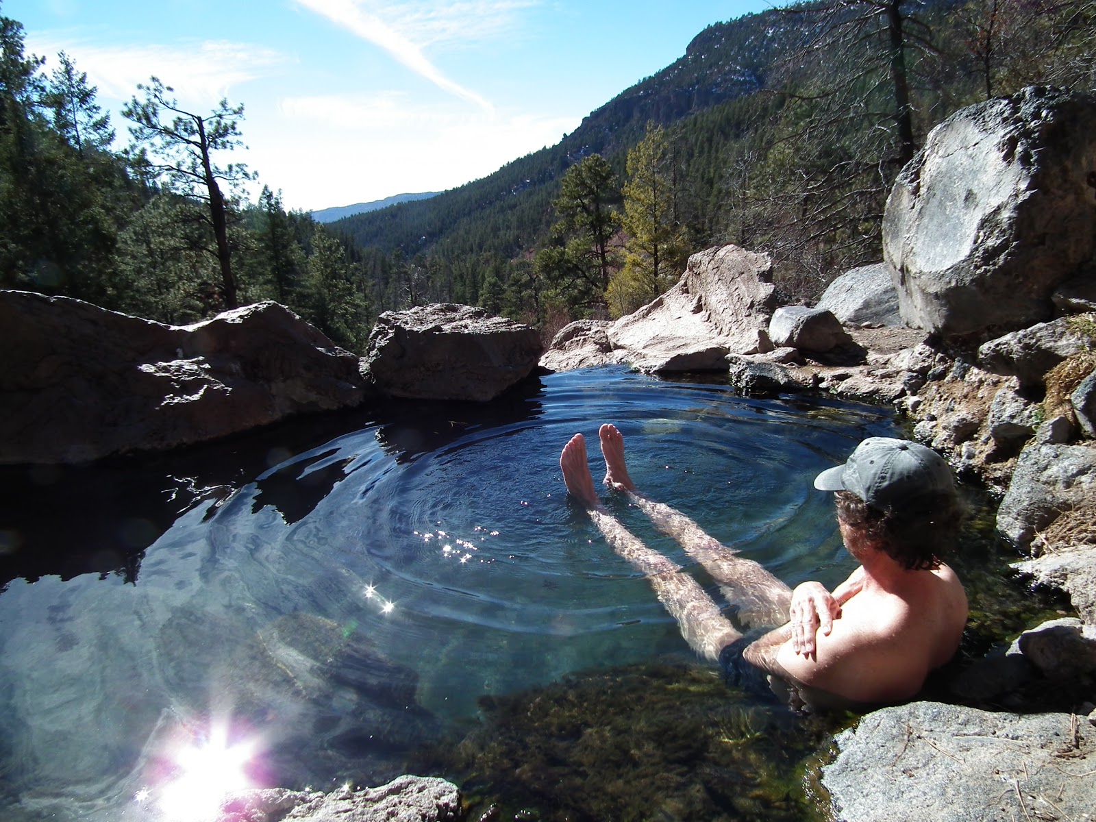
It’s near noon on a delightfully warm and sunny, midwinter’s day and the steaming waters and impressive view at the Spence Hot Spring are soothing one man’s worries away.

“It doesn’t get much better than this,” said Bob of Albuquerque, who had called in sick, grabbed his bike and jumped aboard the train to Bernalillo where he caught the bus to Jemez Springs.

The hot spring is just one of several in the Jemez Springs area where visitors can enjoy a brisk hike in the woods and cap it off with a soothing soak in a natural hot spring.

Bob, who politely declined to provide his last name, said his midweek, mental health day, was made all that much better by the fact that he could use public transportation to get out of town.

“It’s a little known fact that you can take the train out to Bernalillo first thing in the morning and the bus to Jemez Springs is waiting there for you,” he says. “And it’s free with your train ticket.”

Unfortunately the morning train from Santa Fe arrives about 20 minutes too late at the 550 station in Bernalillo for riders to take advantage of the outbound Jemez Springs bus.

But being from Albuquerque Bob was able to take advantage of a great break in the weather and call dibs on the steaming pool located high on a hillside with a great southerly view of the Jemez Valley.
A bridge across the Jemez River provides access to Spence Hot Springs.
Spence Hot Spring is located about seven miles north of Jemez Springs off State Road 4 between mile markers 24 and 25 where the parking lot is currently under renovation along with trail improvements to the spring. 

The spring’s close proximity to the roadway makes it one of the area’s more heavily used but on this Tuesday morning it sees just a few visitors.

Just down the road at the Battleship Rock parking area one can find trail #137 and a two mile hike to McCauley Warm Springs where the clear pools of warm water are bigger and feature tiny minnows that tickle as they nibble at your skin.

These pools see less traffic during the week due to their remote location and can usually be enjoyed with little or no other company. 
Battleship Rocks looms large and beckons hikers to McCauley Warm Springs.
But those who are seeking a real workout in getting to a hot spring should consider hiking in to the San Antonio hot springs located alongside the creek bearing its name.

This hillside hot spring is a cult favorite among winter hikers due to its remoteness, steady supply of good hot water and the fabulous view.

One can follow Forest Road 376 north off State Road 126 to reach it and expect to hike in about 12 miles, round trip. The forest road is closed to vehicles in the winter.

Another hiking route follows San Antonio creek along an old logging road found just across State Road 126 from the San Antonio Campground. This roundtrip hike covers about 10 miles, crosses some private land and ends at the intersection of Forest Road 376 just below the springs.

Others seeking an even shorter route to the San Antonio Hot Springs have dropped down to the river trail through Ice Cave Canyon from Thompson Ridge Estates. This shaves several miles off the hike but is naturally a more difficult and adventurous hike. 
A snake and lizard  are formed by nails hammered into an embedded timber at Soda Dam near Jemez Springs. 
Either way, the trip is usually worth it and may be all that much easier this winter due to a lack of snow fall. 

Consult the Santa Fe National Forest map for more detailed directions to these sites or visit the Jemez Ranger District office on State Road 4 outside of Jemez Springs for more information.
Visitors to these hot springs should pack swimsuits as it is technically illegal to skinny dip in the pools.

Bathers should also be aware that the warm waters may contain bacteria that can cause serious illnesses such as meningitis and should avoid getting water in the nostrils or other body entrances.

Those seeking a hot mineral bath without the hike will find a public bath house within the village as well as the Giggling Springs bath house, both located in downtown Jemez Springs.

And after a full day of soaking visitors may want to drop in to the Los Ojos Bar in downtown Jemez Springs and experience one of the last of a dying breed of real, rustic, New Mexico roadhouses. 
 

If You Go:
From Santa Fe take US 84/285 north to Pojoaque and take State Road 502 to State Road 4 through White Rock and then up the mountain past the Valles Caldera and down to Jemez Springs. For an alternate route home continue on State Road 4 through Jemez Pueblo to San Ysidro and follow U.S. 550 to I-25 at Bernalillo.

Enjoy a beer or two but party responsibly and arrive alive.


Sunday, February 13, 2011

Lonely BLM Backcountry Byway Beckon's those Bored by the Highway

By Karl Moffatt
If you’ve ever wondered what was up in those hills to the east of I-25 as you traveled south near Socorro, New Mexico then the Bureau of Land Management (BLM) has a backcountry byway for you to explore.

Twenty-four miles of good, dirt, road that rambles up through those hills featuring interesting rock formations, curiously colorful peaks and plenty of lonely open space, to wander through.

It’s the kind of road and backcountry landscape that few may see if they stick to the pavement during their travels throughout the state.

Which is exactly why the BLM has designated the road as one of five back country byways here in New Mexico that motorists can follow to find distinctive scenery found only off the beaten path.
Looking west towards Socorro.
Those who intend to visit the byway should download a copy of the Quebradas byway’s brochure which includes a map and the highly informative field guide “A Geological Guide to the Quebradas Backcountry Byway”.

The field guide’s chapters and information correspond to numbered stops found along the byway and is a richly detailed document written by Peter Scholle, State Geologist and Executive Director of the state Bureau of Geology and Mineral Resources at New Mexico Tech in Socorro.

Both documents can be found on the BLM’s website at www.blm.gov. Just navigate to the New Mexico section, click on Outdoor Recreation, then on Outdoor Activities where you’ll find the back country byways icon which leads to more detailed information about this and the state’s other back country’s byways.
Tombstone topography.
During a recent early winter visit to the Quebradas byway, the road proved to be in good condition and passable to even careful drivers of a passenger car, however, such an attempt when wet would be inadvisable.

Upon venturing up into the barren hills one may experience an uneasy sense of remoteness before the exhilaration of discovery sets in. Having some water, a cell phone and a spare tire on hand should help alleviate any hesitancy to follow this road.

During the trip one might find themselves stopping frequently to check things out, in addition to consulting the field guide.

One particular hillside featured great sheets of loose shale rock cascading down from above and exposed bands of colorful rock strata. This hill begged to be climbed and rewarded those who did with a stunning view back across the valley to the opposing mountains.
Shale rock like that used on patios can be found here.
At another stop one can see rows of rock jutting from the hillside like tombstones while just around the corner, a couple of cows stood by the road, staring incredulously at the passing vehicle.

And over the course of an afternoon of cruising the back country not a single other vehicle was seen.

It was the kind of road that went well with a cold beer and second gear and invoked memories of the days when casual, drinking and driving in much of our rural, remote state was a harmless pastime, not a horrendous crime.

Outdoors New Mexico's original road warrior.
The rambling 24-mile drive starts on the outskirts of Socorro for those southbound on I-25.

Jump off the highway at the first exit by the State Police headquarters, number 152, and then head towards the river and Escondia Lake. Cross the river just past the lake and then head south a little ways on Bosquecito Road to the intersection of County Road A-152 and follow into the hills.

Just follow the signs, if they’re still there.

From this direction the byway ends at US 380 about 11 miles east of San Antonio, gateway to the Bosque Del Apache bird sanctuary and home of some of the best green chile cheeseburgers in the state at the legendary Owl Bar and Café and now famous, Manny’s Buckhorn Tavern.
Cook, Richard Beltran, serves up one of the legendary chile cheese burgers at the Owl Bar and Cafe in San Antonio, New Mexico.
The back country byways are part of a nationwide BLM effort to promote visitation to scenic areas by motor vehicle in part because studies show a vast majority of Americans drive for pleasure.

New Mexico boasts five scenic byways including the Quebradas which means “breaks” in Spanish, the Guadalupe outside of Carlsbad, the Wild Rivers near Taos, the Chain of Craters through Malpais and the Lake Valley byway near Hillsboro.
Hills off US 380 upon emerging from the Quebradas.
For more information about these and other scenic byways check the National Scenic Byways Program website at www.byways.org.

If You Go: From Santa Fe take I-25 south to the Escondia exit, number 152, head east towards the river, past Escondida lake, across the river to Pueblitos, take Bosquecito Rd. south to County Rd. A-152 and follow into the hills. Emerge at US 380 and head west back to I-25.


Popular Posts